


The Front Line of the Ocean, Protecting Tokyo Against Flood Damage
The Port of Tokyo is an international trading port that serves as a foundation for the industry and everyday lives of the 40 million people who live and work in the Tokyo metropolitan area. It is also, however, located at the furthest end of Tokyo Bay, which opens in a southwesterly direction towards the sea. This, combined with the shallow waters in the bay, makes the area particularly vulnerable to phenomena like storm surges. The pumping of groundwater and mining of natural gas in the eastern coastal area from the late 1880s to the 1970s, has also caused land subsidence, resulting in spread of low-lying land. Even today, roughly 20% of the 23 wards of Tokyo—approximately 124 square kilometers, housing 1.5 million Tokyo residents—consists of so-called "zero-meter zones" that fall below sea level at high tide.
Coastal Protection Facilities to Protect Low-Lying Areas
The storm surge project for the Port of Tokyo began in 1934. The lessons wrought by Typhoon Kitty, which hit Tokyo Bay in August 1949, and the Vera(Isewan) Typhoon of 1959, which resulted in some of the worst storm-surge damage the country had ever seen, were then used to establish full-scale projects to counter such storm surges. Currently, a development plan is being formulated to respond to earthquakes and tsunamis, that have been a part of the public consciousness since the Great East Japan Earthquake in 2011. This involves developing systems to respond to the largest-scale possible disasters.
Masuyama Ryota of the Planning Section, Port Planning and Construction Division, Bureau of Port and Harbor, explains the mechanism behind the storm surges brought about by typhoons and strong winds. "The height of the tide changes depending on the balance between atmospheric pressure and water pressure. Lower atmospheric pressure means less pressure on the surface of the ocean, which lets the water pressure push the surface upwards. The tide level at one atmospheric pressure (1,013 hectopascals) has a deviation of zero. When the atmospheric pressure drops by one hectopascals, the sea level rises by about a centimeter. Storm surges from typhoons also have what is called the 'wind set-up effect,' in which waves gain height as they move closer to the land."
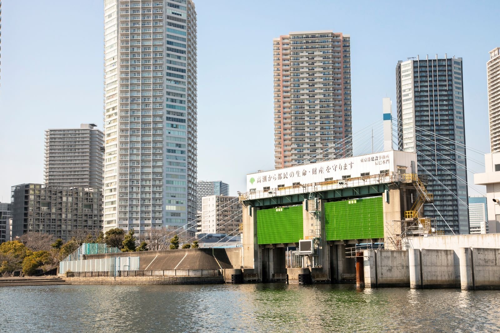
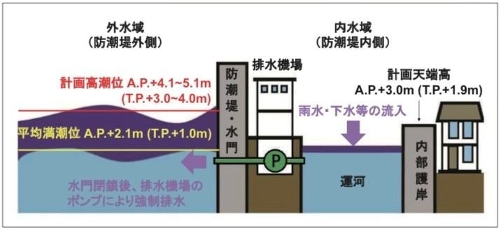
In the Port of Tokyo, coastal protection facilities—such as floodgates, inland locks (tide gates installed on roads), seawalls, and pump stations—continue to be built around low-lying areas to protect the lives and property of the Tokyo residents who live beyond them. "The seawall, when complete, will be high enough to protect against the kind of storm surges seen in the Isewan Typhoon. This will be about A.P.*+ 4.6-8 meters, which factors in the sea level at high tide, plus the rise in sea level due to storm surge, as well as the existence of waves." The height of the seawall is well over the A.P. + 3.7 meters that had been established as the maximum high-tide tsunami level by the Tokyo Metropolitan Disaster Management Council at the time of the Great East Japan Earthquake. Based on these figures, it is clear that the seawall is also able to handle tsunamis. Additionally, pump stations have been installed in various locations in the Port of Tokyo to force water drainage and prevent rains and flooding from raising the water levels in the canals when the floodgates are closed. The system is thus double-layered, with the seawall working to block water from the storm surge on the ocean side, and the pump stations draining water that has found its way inland and has nowhere else to go.
*A.P. is an abbreviation of Arakawa Peil, a standard used to measure the height of tides, etc. The zero-meter marker at the water level observation station in the Shinkawa area of Chuo City—generally the sea level at the lowest tide—is considered A.P. ± 0 meters.
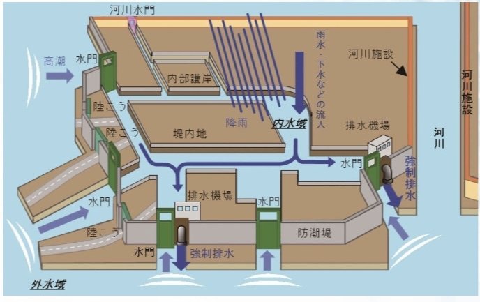
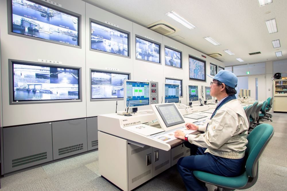
The Storm Surge Management Center of the Tokyo Port Construction Office are responsible for operating the floodgates and flood embankments during the occurrence of typhoons, earthquakes, and other phenomena that can cause abnormal tide levels. The floodgates and embankments are installed on canals and roads respectively and are normally kept open so as to allow the passing of ships, the flow of neighboring rivers, and the movement of people and vehicles. During times of emergency, however, they are immediately closed, after which they work in conjunction with the seawalls to prevent inland flooding. There are two Storm Surge Response Centers—one in the east (Tatsumi) and another in the south (Konan). Those at the centers use displays to monitor the camera footage and information signals of each facility and are able to use remote operation to respond to any unexpected situations. There are also plans in place to install an AI water-level prediction system in order to support these operations, with the current goal being to refine the accuracy of this prediction model.
Handling the Effects of Climate Change
Another factor that has become a problem in recent years, in addition to storm surges and tsunamis, is the rise in sea level due to global warming. "As for the rise in sea level, we've set the height we'll need for seawalls in the future based on the values stipulated by the IPCC.* What this means more specifically is that for every increase in temperature of two degrees Celsius, we presume the water level will rise by a maximum of 60 centimeters. And we calculate the increase in seawall height based on that. But there are factors within climate change that are hard to read, so we're first setting the guideline to the height we'll need in 50 years. Then we'll monitor the situation, review the plan every ten years, and move through development in stages."
*IPCC stands for Intergovernmental Panel on Climate Change. An organization with 195 member countries and regions, it provides a scientific basis for the policies of national governments when it comes to climate change.
In recent years, cities, town councils, and shopping districts have come together to push for environmentally friendly developments that allow residents to enjoy waterfront spaces during normal, non-emergency times. It is important for residents of this urban space to be familiar with the pleasant Bay Area and riverbanks during normal times, while at the same time having an awareness of the need for disaster prevention against coming natural disasters.
The Tokyo Metropolitan Government (TMG) has established the "TOKYO Resilience Project" with a total budget of 15 trillion yen, in order to prepare against five major potential disasters—storm and flood damage and earthquakes, of course, but also ash fall from volcanic eruptions, power/telecommunication disruptions, and infectious disease. Through the project, the city is also promoting its safety-minded urban development to the wider world. Moving into the future, the TMG will also work with start-up companies to protect the lives of Tokyo residents by utilizing new digital technologies and other resources.
*Affiliations, job titles, etc., are as of March 2023.
Photos by Fujimoto Kenichi
Translation by Amitt